"Welcome to Crest of a Star; these maps and other graphics are only for playing D&D type games. They are copyright and not to be used for other purposes. If you have them on your site, please remove them. Thank you."

"My maps are free. If you purchased them, you got scammed."
"Not for redistribution or resale. Hyperlinking from Pinterest or other such share sites is prohibited."


Posted

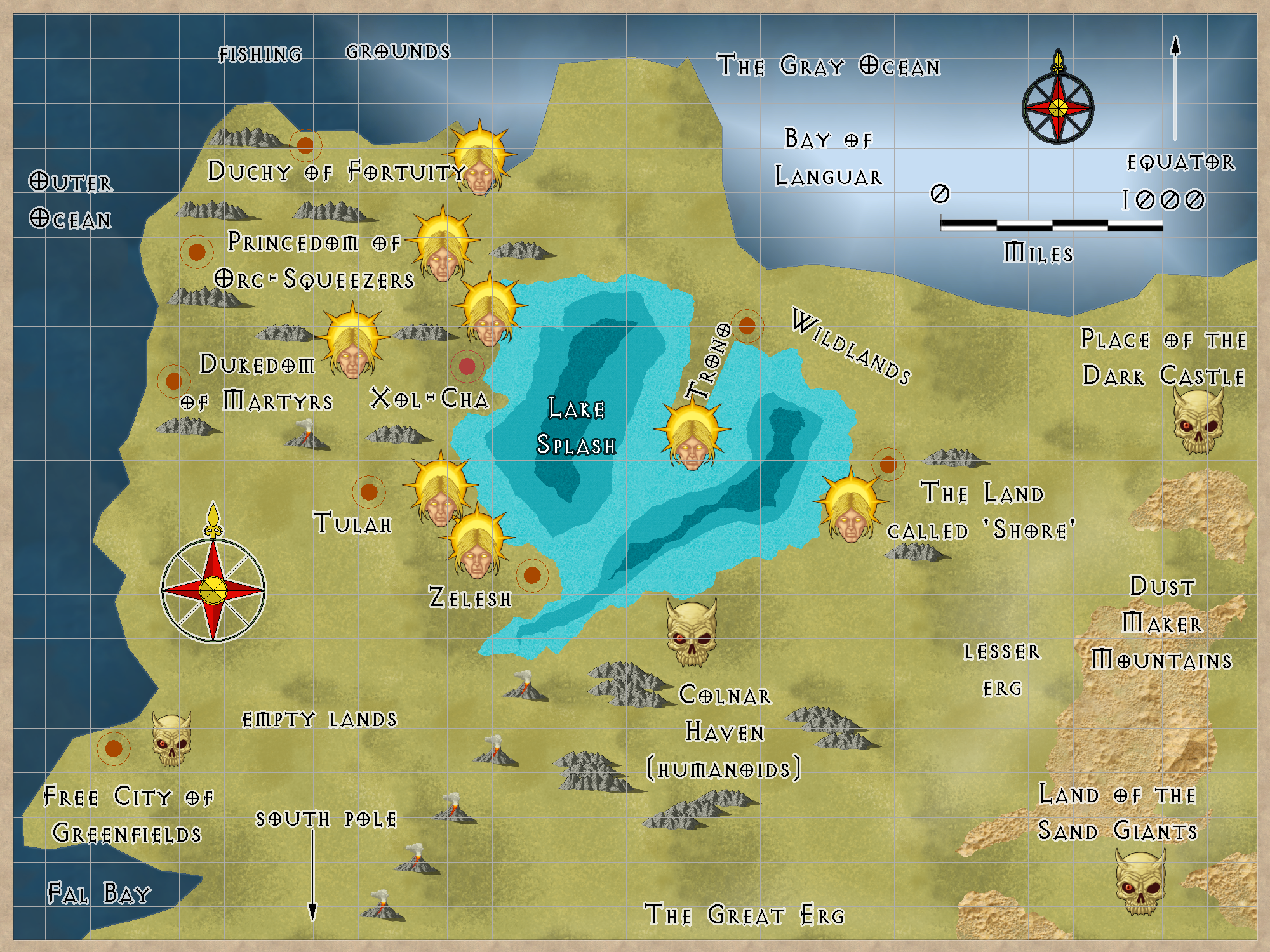
A small nation next to Splash Lake. The capital is Gronash.

They know about Trono, but trade is difficult due to the land attacks from orcs and bugbears.

Two small forests, a small wooded area. The rest of this small nation has trees here and there, but nothing to make it easy for attackers to hide behind.

Few thieves live here. Most have been killed off when a small number were found to be working with Orcs to harm people here. The Shorelans decided to not take any more chances and dealt a death blow to anyone with thief skills.

The few remaining thieves are part of the local army, and must carry documents proving this with them at all times.


Author
Categories South Hemisphere, The land called 'Shore'

Posted

This is the area where most adventures took place, Trillolara.


Map Key

1) Quasqueton [ ruins] from TSR’s B-1 module newmap and descriptions.

2) Fondfield [ military area commander’s headquarters ] where the player characters lived
while adventuring in Dtrig 1, Dtrig 2, Khilla Keep, and Sraa Keep

3) Sraa Keep [ ruins]

4) Dtranyo Castle [ manor house ruins], now rebuilt and owned by player characters
and converted into a walled stone castle.

5) Dtillan Orsti [ seaport ] players characters arrived here from Fondfield.

6) Castle Dwarfbas [ home of Dwarf King ]

7) ruins

8) Tower Dtranyal [ ruins] unexplored by the player characters and unmapped by me

9) Dtrig 1 [ ruins] explored. Very old style rectangular fort

10) Dtrig 2 [ ruins] explored. Very old style rectangular fort

11) Dwarf Home [ ruins] partially explored, all underground.
12) Sallor, Trillolara capital city

13) Forlorn Keep

14) Fortress of Krag the Stout-Hearted.

New map: June 28, 2016


Author
Categories South Hemisphere

Posted

Lawful Nomads to the North, West, and Southwest. Adventurers heading for the Evil Hills will not be bothered as the Nomads consider them slightly crazy.

Evil brothers fighting over their father’s lands, The Land of Strife.

The edge of Trillolara and the great seaport Dtillan Orsti. Beware the con artist and the pickpocket. Far from the capital city of Sallor, talk is evil walks here and not just minor thievery.

Dwarfbas, the capital of the Dwarf King.

The Evil Hills, down deep below them is Dwarf Home. A long abandoned area of multiple levels and forgotten Dwarven Glory.

Some say it is cheaper to take a ship from Dtillan Orsti to Dwarfbas than travel overland. And there are others who say it is better to go overland.

Why is the island Traql not shown on this map ? Many in this area cannot see it, even if they sail right past it. A few sages know it is there. They don’t talk about it. Some great magic prevents many from noticing it.

Rich finds, many monsters, and evil people, disappeared people likely held captive in Dwarf Home, adventurers go in, and not all come out alive, or maybe the entire adventuring party are never hard from again.

Dwarven Artifacts of armor and gems, the Dwarves in Dwarfbas will pay handsomely for such items return.

Map updated: Jan 30, 2015.

A closer look at the Dwarf Home area, Skull with eye marks the entrance found by earlier adventurers. But what about the ruined town and the ruined keep ? What are they for ?

The Hill Dwarves are where treasures found must be inspected to make sure adventurers aren’t taking away Dwarven Heirlooms.

Added Jan 31, 2015

Surface entrance found previously by other adventurers. Slightly modified from an earlier map. Well.. very modified.

These walls don’t appear and disappear. They are solid, well, okay. The trees are part of the few that grow well in this area. Many are withered and distorted.

The stairs lead down into Dwarf Home.


This is the original sketch map I showed my players. It is no longer accurate.


Author
Categories South Hemisphere

Posted


Dark Blue for the ocean that sustains them, the black wandering line of the first battle groups that went inland after the Green Cloud saved them to look for Evil and remove it from Dank Forest. The semi-circles of planned searches for Evil finished the cleaning of the land. The Eye to show they are on watch for Evil.


Note the Tooshla Henge north east of Brillar. The capital city of Gashtra, and evil nation, is named Tooshla.

Dank Forest

This nation is a total monarchy allied to Trillolara. Trillolara is Southeast of here. This land is covered by an almost continuous fog or rain due to a warm northerly and cold southerly sea currents meeting just off-shore. The king charges exorbitant taxes on any treasures found. The Capitol is Brillar. (Alignments: CG, CN)

New map: Jan 30, 2015.

area around Brillar, Dank Forest

Mad Krongo’s Keep is the location of one adventure by a store game group. Its located in the central pass through the hills. Meldale and Bigdale are nearby villages. I cannot find the maps and info. I’ll have to rewrite them based on my notes.

Hinge Road goes inland, past Mad Krongo’s Keep, ruins, and on into the interior.

The Coast Road goes for miles, into loneliness. There are a few towns near Brillar, but not much beyond along the coast road. There are a few castles and keeps further up the coast here, but even fewer travelers.

Why does Brillar exist then ?

The Plains of Dareth are controlled by Evil, so any imports must come by sea.


Author
Categories South Hemisphere, Dank Forest

Posted

A brief mention of the roads first. Town Circle goes around the entire town in a large circle just inside the walls. Most of the time the inhabitants of Fondfield will tell a newcomer how to determine what part of Town Circle is under discussion or as directions to finding someone.

They might say, “As you enter East gate, off to the left is Left Town Circle, Off to the right is North Town Circle. It continues on around. When either direction gets you to the west side of town, that is West Town Circle.”

They don’t tell rude people about the road name changes… the changes aren’t marked on any sign posts.

Castle Road is over by the Castle, numbered 14 on the map. Queen’s Road is the central North-South road.

North Road and South Road are both in the northeast corner of town, north of The Questors. South Road homes are where some of the members of The Questor’s live. Shan-Tor’s Road, left side of the map is named for Queen Sharalan’s Consort.

D1 through D12, on Chas-Lo road, are duplexes. One family upstairs with an outside stair, the other family lives downstairs with a separate entrance.

H1 through H30, on Tick-Tock Road, are single family dwelings. Many of the families here work in the Inns, and in various stores.

M1 through M2, on Merchant Way, are the two story homes of members of the Merchant Guild.

Q1 through Q3, on South Road, are the homes of members of The Questors.

S1 through S17, on Shop Road and Small Shop Road, are shops. S18 is a storage shed some of the shops share.

T1 through T2, on the north part of Shar-Tor’s Road, are the homes of the military training serjeants.

[To be continued as I have time.]


Author
Categories South Hemisphere


Privacy policy: I track IP addresses and pages looked at out of a vague curiosity to learn what pages are looked at on my site. After a set period, this information is deleted. No personal information is permanently kept.


[ Copyright © by Jim, 1980-2050. All Rights Reserved. ]

[ Except where noted, and where copyrights are held by others. ]